OS Explorer ACTIVE OL4 The English Lakes North Western area: OL 04 (OS Explorer Map Active)
M**E
Mapping works of art, and well deserving of a five star rating!
These Ordnance Survey 1:25,000 scale Explorer maps are, in every sense, works of art! - They have “evolved” over the years since they were first introduced, and occasional minor changes to detailing and symbols etc. continue to this day. And these days, the mobile download bonus is a superb additional extra.As for ease of use “on the hill”, it has to be said that the paper maps can be somewhat cumbersome, as they cannot be opened to show every part of the map without fully unfolding – and in a howling gale that can be a very difficult process! – In that respect, the “ingenious foldability” and 100% waterproofing of Harvey Superwalker XT25 range is much superior.However, with the one exception that Public Rights of Way, (which may or may not exist at all as tracks on the ground), are shown much more prominently than paths that actually do exist on the ground, the mapping is truly superb. – Actual paths are shown as very small black dotted lines, whereas Public Rights of Way are shown much more boldly, as green hashed lines. I personally find that to be a major niggle! – When I’m out on the hills in dense mist, I want to know where the real world paths on the ground are – not where designated public rights of way are!!! – If anything, the actual paths on the ground should be shown more boldly than rights of way!Having said all that, especially when being viewed from the comfort of an armchair, there is nothing to beat the quality of Ordnance Survey mapping. In my humble opinion, still fully deserving of a five star rating here on Amazon!
H**Y
Correct area
Map was needed for a Lake District visit (26th-29th July)
A**R
Hiking
It was clear and easy to understand
L**S
Very useful
Bit help on walks
J**H
A great printed map
This OL map covers about twice the terrain the original versions did. Contains all of the great map work we expect from Ordnance Survey.2 cons, double sided so you can end up flipping the map over at times and not waterproof, although the paper does feel slightly shiny.Also the downloadable version requires subscription, about £30 per year, £3 per month, which is not clear until you've downloaded the software & entered the unique map number. This is slightly annoying considering the price of the map.
D**D
Useful guide
We did not really use the map, but the download version that comes with it was great. It works offline, so you download and can then plot walking routes. The app also advises you if you have gone off route, really good for someone who hadn't visited the Lake District before and was new to plotting routes. It made our trip very enjoyable.
S**S
MAAAAAAAAP
It's a waterproof map, not much to say, map, tick, waterproof, tick. Picnic blanket for wet grass because you forgot it, tick, great big sail to blow in your face when it is windy, tick.
C**T
Perfect!
I love OS maps! A must for any hiker, shame though lake district is in 4 parts. that's 4 maps and about 30£. I like digital bit a lot. Very useful if you don't want to ram about with big map. Works offline as well and you can plan routes and save them.
H**E
Hiking the Lake District, northwest portion...
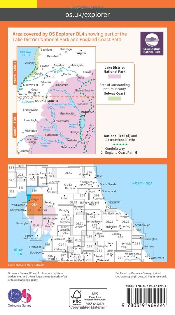
If you plan to hike in the Lake District, it helps to have good maps. This particular Ordnance Survey Explorer map covers the northwest quadrant of Britain's most popular national park, from Cockermouth and the shores of the Irish Sea to Keswick and Borrowdale. Coverage includes Crummock Water, Buttermere, Derwent Water, and the northern approaches to Great Gable.The scale is a very user-friendly 1:25,000, with easy-to-read graphics, and a mobile download. The map cover is plasticized. The map itself is paper and will need protection from the famously wet weathers in the Lake District. Highly recommended to the enterprising traveler.
K**.
Nicht nur eine einfache Karte
Das ist DER Anbieter für detailgenaue Karten in GB. Die Lieferung entspricht exakt der Beschreibung.Nettes Feature: in der Karte ist ein Rubbelfeld mit einem Code. Mit diesem Code kann man sich über die hauseigene App (OS Maps) genau diese Karte auf sein Tablet oder Handy downloaden.Also erhält man zwei Kartenversionen, analog und digital zu einem Preis!
Trustpilot
2 weeks ago
3 weeks ago